Big Cedar & Kennedy Falls: A Hike That Doesn’t Need a Summit
I’ve done hikes with bigger views, steeper climbs, and more dramatic summits. The Big Cedar and Kennedy Falls trail is not that kind of hike — and it’s one of my favourites anyway.
The Big Cedar Kennedy Falls hike doesn’t give you a mountain panorama at the end. There’s no “I climbed something” feeling when you reach the waterfall. What it gives you instead is deep, quiet, old-growth rainforest: the smell of pine and loamy earth, moss covering everything, ferns taking over every available surface, and the particular hush that comes from being somewhere that hasn’t been managed or manicured. An unsanctioned, unmaintained trail through genuinely wild Pacific Northwest forest, with a 600-year-old cedar tree and a beautiful cascade waterfall as the rewards.
Sometimes that’s exactly what a hike should be. No summit required.
Trail Details
Location: North Vancouver, BC — Mount Fromme / Lynn Valley area
Distance: ~10 km return (6.25 miles)
Total elevation gain:~430 m (1410 feet)
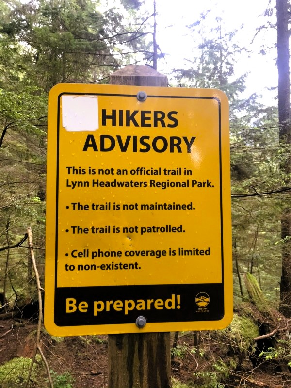
Difficulty: Intermediate — unsanctioned, unmaintained, some scrambling
Trail type: Out-and-back
Time: 4–5 hours
Trailhead: Mount Fromme parking lot, top of Mountain Highway
Season: Year-round; May is best for the falls (snowmelt), end of summer for easier creek crossings
Dogs: Yes
Getting There
Parking is at the Mount Fromme parking lot at the top of Mountain Highway in North Vancouver — about 30 minutes from downtown Vancouver. Note that the park gate closes overnight, so check current hours before going to avoid getting your car locked in.
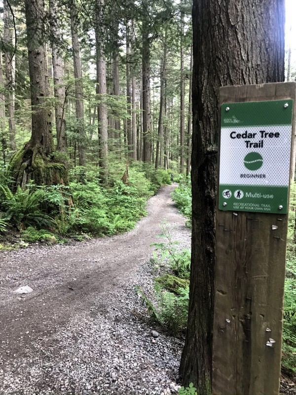
From the parking lot, continue past the gate up the old gravel mountain road. Before the first switchback, a gravel trail drops to your right — this is the start of the Cedar Tree Trail. Follow it left, stay right at the Kirkford Trail junction, and you’re on your way.
Note: there are multiple ways to reach the trailhead (from Lynn Headwaters parking lot, or via street parking lower down), which add distance but allow different approach options. The Mount Fromme lot gives you the shortest route to both highlights.
The Trail: What to Expect
The First Section: Mountain Bike Territory
The early part of the route runs through an area shared with mountain bikers — it’s important to be aware and give bikes the right of way when paths converge. This section transitions to the unmaintained trail at around 1km in, and the character of the hike changes noticeably from there.
Into the Forest
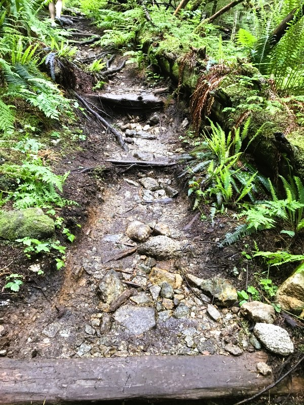
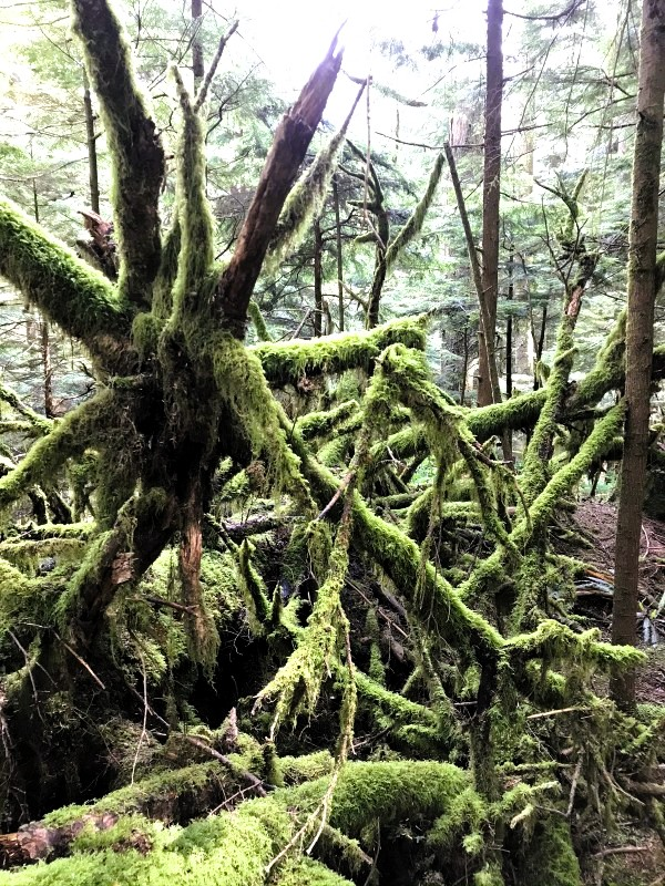
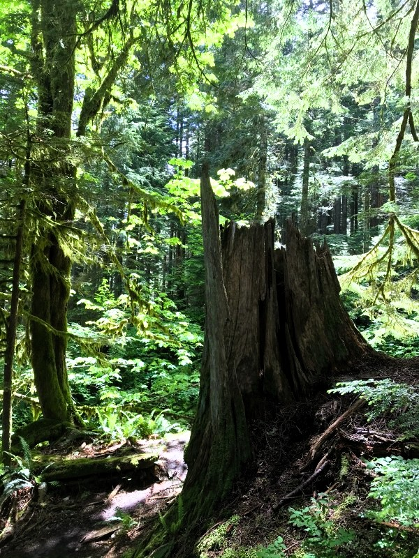
Once you’re on the unsanctioned trail, the forest closes in. This is the Pacific Northwest at its most archetypal: Douglas fir and western red cedar overhead, sword ferns carpeting the ground on both sides, everything coated in moss. The air smells of pine and damp earth — that particular combination that’s hard to name and immediately recognizable once you know it.
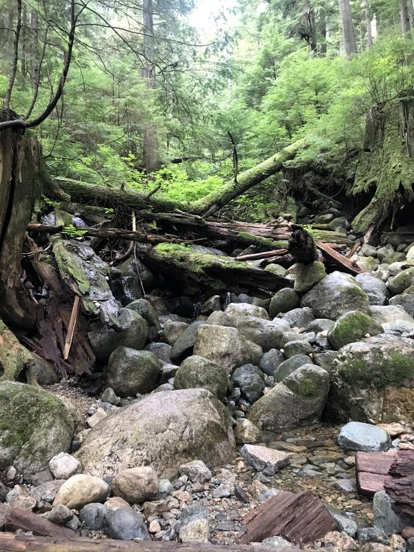
The trail is genuinely rugged. Lots of roots, slippery creek crossings, muddy hills, and numerous fallen trees to climb over or under are all part of the experience. Root ladders in the steeper sections, small rock piles to scramble over, narrow stream crossings where you pick your way across rocks and try not to slip. Pay extra attention to the trail markers, as it can be easy to lose the trail in some sections where there is a lot of deadfall.
Bring waterproof boots. This is not a dry trail.
The Big Cedar
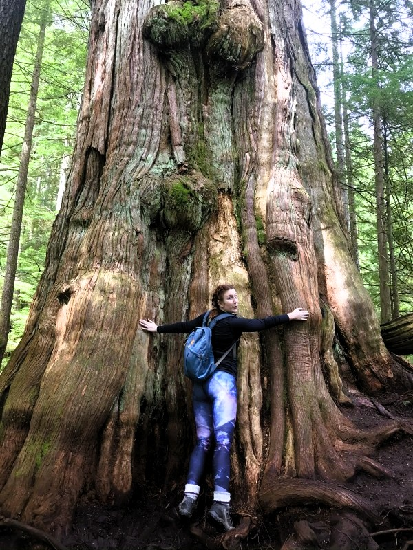
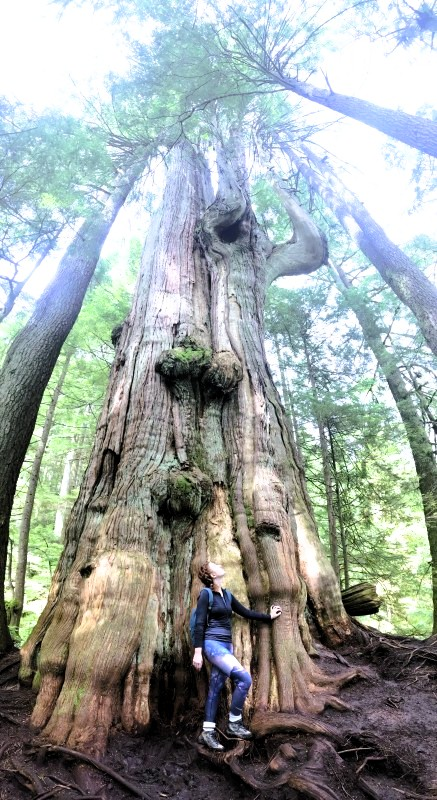
The Big Cedar is a giant cedar tree that is over 600 years old — one of the largest remaining old-growth trees on the North Shore, sitting less than 100 metres from Lynn Creek.
On the way in, I kept seeing large trees and wondering each time if that was the one. A big cedar here, another impressive trunk there — each one making me think we might have arrived. We hadn’t. When we finally reached the Big Cedar, there was absolutely no doubt. It simply exists at a different scale to everything around it.
The bark is what I remember most clearly. Old-growth cedar bark is different from younger trees — thinner somehow, more papery, with a texture that reminded me of aged skin. The trunk is enormous — trying to wrap my arms around it barely covered half the circumference. Looking up from the base, the canopy is far above.
There’s a reverence that comes with being near something genuinely old. Six hundred years of existence on this hillside. Whatever was happening in the world when this tree was a seedling.
Important current note: The survival of the Big Cedar is at risk due to significant erosion occurring around the base of the tree. A fence has been installed around the tree — please respect any boundaries and don’t get too close. The tree’s survival depends on people giving it the space it needs. Admire it from a respectful distance.
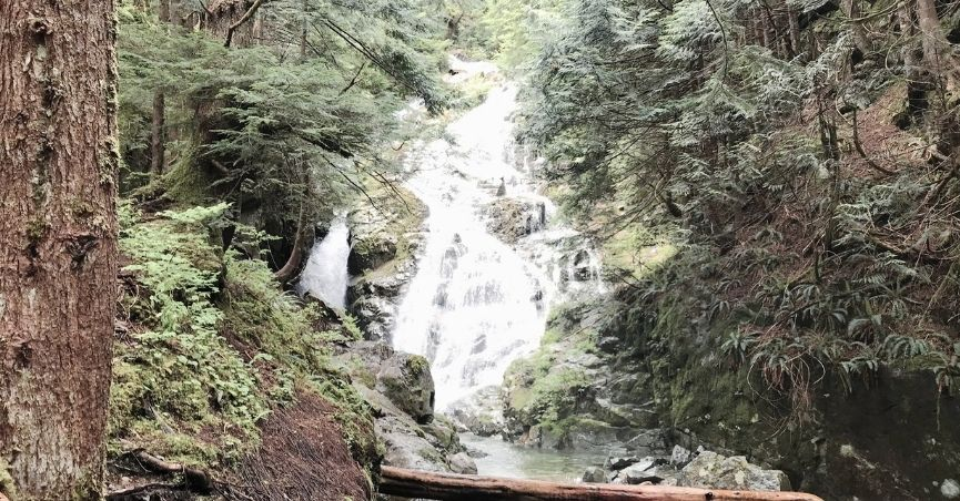
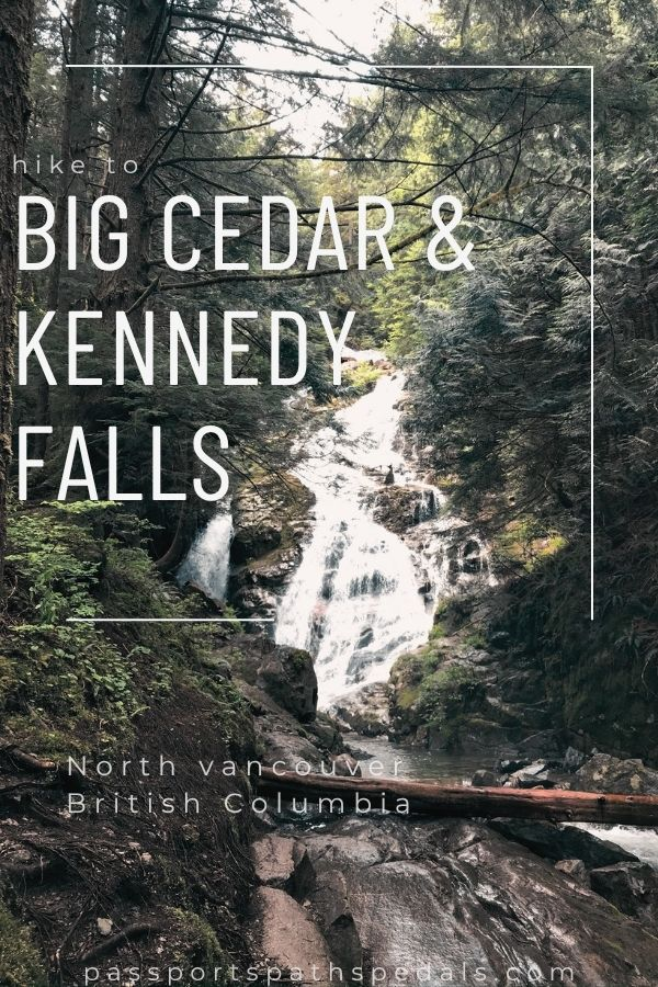
Kennedy Falls
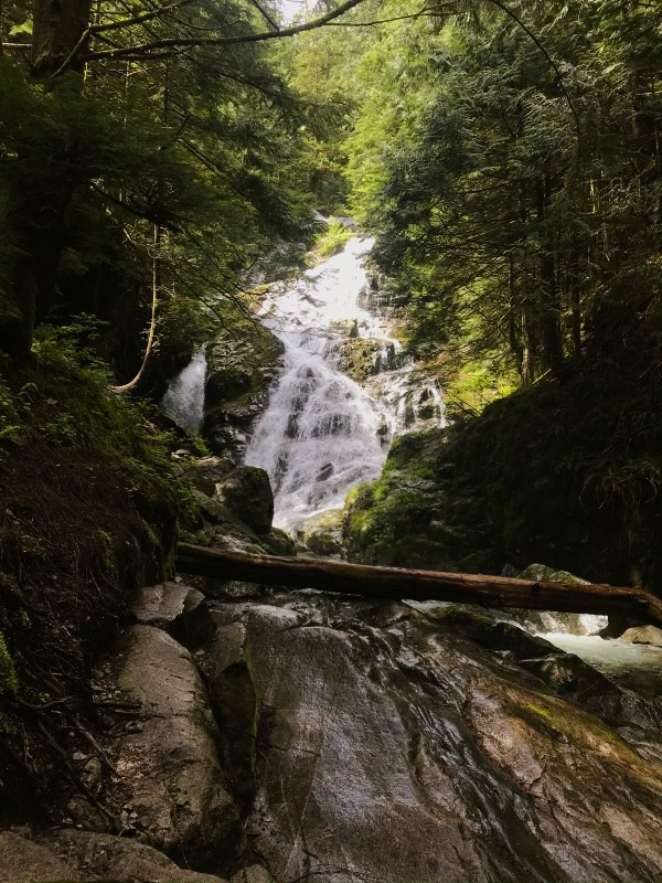
Continue past the Big Cedar for another stretch of forest trail — more roots, more ferns, more creek crossings — and the sound of the falls arrives before the view does.
Kennedy Falls is not the typical kind of waterfall. It doesn’t crash over a cliff edge in a single solid column of white water. Instead, it spreads across the face of a rugged rock surface, fanning out as it descends — multiple streams finding their own paths down the stone, the whole face animated with moving water. This type of cascade is my favourite: more complex visually, more interesting photographically, and somehow more integrated into the landscape than a single-stream plunge falls.
The viewpoint sits above the river below — you can’t get right up to the base — but the straight-on perspective from the viewing area is excellent. And for photographers: Kennedy Falls is often considered the most impressive waterfall on the North Shore, and a slow shutter speed (1/4 second or longer on a tripod or stable surface) turns the cascading water into something silky and luminous. Bring ND filters if you have them. The results are worth it.
We were alone at the falls. June 2020 — early COVID recovery period in BC, mid-week, an unsanctioned trail that doesn’t appear on the standard North Shore hiking lists. The solitude felt like a bonus rather than a coincidence. It’s the kind of place that feels like a discovery even when you found it on a map.
When to Go
Kennedy Falls is particularly lively during snowmelt in the late spring, with May usually being the best month to visit for the most dramatic water volume. We went in June and found it beautiful — still strong flow, manageable creek crossings.
The end of summer is the best time if you want to avoid the worst conditions — creek crossings are at their lowest and easiest. The trade-off is reduced flow at the falls.
The trail is doable year-round, but not recommended with snow on the ground — the roots and creek crossings are challenging enough without ice added to the equation.
Practical Notes
Boots: Waterproof hiking boots are non-negotiable. The trail involves multiple creek crossings and consistently muddy sections regardless of recent weather.
Navigation: The trail is unsanctioned and not maintained, which means limited signage. Download an offline map (AllTrails or Gaia GPS) before you go — cell service is unreliable on the trail. Several people have gotten turned around in sections with heavy deadfall.
Mountain bikers: The first section of the route shares space with MTB trails. Stay aware and give bikes right of way on shared sections.
The gate: The Mount Fromme park gate closes overnight. Check current hours before parking inside the gate to avoid getting locked in.
Difficulty reality check: The elevation numbers on various sites vary considerably — some list 150m, others 430m+. The cumulative elevation due to the rolling, undulating terrain is higher than the net gain suggests. Most fit hikers take 4–5 hours for the full return. Don’t underestimate it based on the distance alone.
Dogs: Welcome on this trail. Keep them under control near creek crossings and be aware of the technical sections.
The Big Cedar fence: Respect it. The tree needs the buffer zone. Stand at the boundary, take your photos, and move on. Its survival matters more than a close-up.
Pin me for later…
You might like these BC Hiking posts: