Weekend Bike-packing: Alouette Lake via Fort Langley
Our first bikepacking trip — and now our go-to early season gear shakedown route. This one started something.
Route Details
Distance: ~35 km each way [70 km total] (22 miles, 44 miles total)
Total Elevation Gain: ~341 m (1119 ft) on the way in, ~200 m (656 ft) on the way back
Type: out and back (with optional overnight)
Terrain: 78% paved, 22% gravel
Time: ~2 hours each way
Camping: Alouette Lake East Beach Marine Campsites (first come, first serve)
Why This Route
This ride holds a particular place in our cycling life. It was our first bikepacking trip together. The first time I loaded up my gravel bike with overnight gear and actually committed to sleeping somewhere I’d ridden to. That version of me, in the summer of 2023, was nervous about the gravel, tired from the climb, and genuinely uncertain whether we’d make it home without falling apart on the one hill and the bridge between the lake and Fort Langley.
We made it. Barely, in my memory.
Since then, this route has become our early-season tradition — the ride we do in spring to shake down the gear, test the legs, and find out what survived winter and what needs replacing. April 2026 was the most recent version, and riding it felt completely different. Easier, more comfortable, more confident on the gravel sections that used to make me nervous. The route hadn’t changed. I had.
That’s a good feeling.
The Gear Reality Check
Part of what makes this route useful as a shakedown is that it’s long enough to reveal problems but short enough that the problems are survivable. Every time we ride it, we learn something.
This most recent trip, the lessons were clear: panniers are not for me. They’re too easy to overpack, and a single rear pannier left me noticeably lopsided in a way that affected balance more than I’d like to admit. We’re moving toward distributing weight more evenly across the bike — handlebar bags, frame bags, front-end loading — rather than putting everything on the back. We’re also looking at lighter, more compact sleeping bags and pads. The gear we’ve been using does the job, but takes up more space than it needs to.
None of this is criticism — this is exactly what a shakedown ride is for. Better to figure it out 30km from home than 300km into a longer tour.
The Route, Section by Section

Fort Langley to Golden Ears Bridge
Starting in Fort Langley is a genuinely pleasant way to begin a ride. The town has a historic quality — heritage buildings, the fort itself, the Fraser River nearby — that makes the first few kilometres feel like a proper departure rather than just leaving the car park.
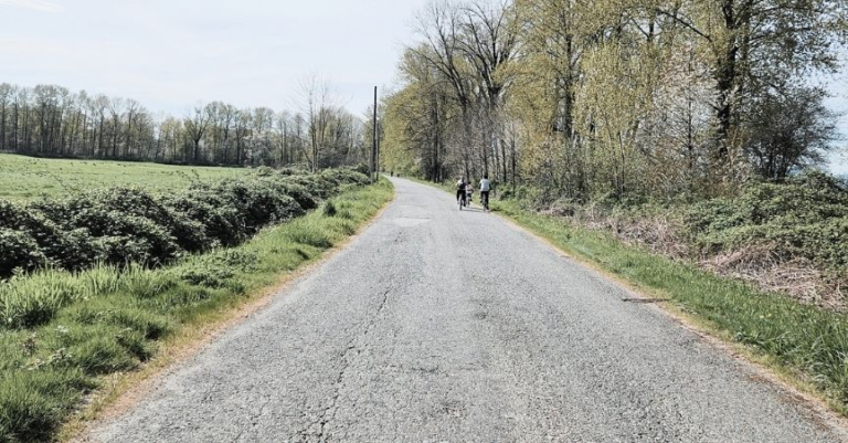
It transitions into more urban riding once you cross the Golden Ears Bridge and hit Maple Ridge, but dedicated bike lanes and paths cover the majority of this section. Golden Ears Way has the feel of a highway — wide, fast-moving traffic — but the shoulder is generous, and it’s a short stretch before you reach the bike path. Once you’re on it, the landscape opens up: farmland on both sides, mountain views ahead, the road ahead belonging to you rather than shared with vehicles.
Consider a stop at The Patch Brewery along this section — a lively but relaxed spot set in a farm field, with a classic red and white barn, lots of outdoor seating, and a beer flight worth stopping for on a sunny day. We haven’t stopped here on the bike yet, but it’s on the list.


Maple Ridge Streets and the Abernethy Way Path
Follow the path along Abernethy Way. Between 232nd and 240th Street, it shifts to road and sidewalk riding through town, but the side roads are fine, and the section along Dewdney Trunk Road is technically a designated bike route. Not the most scenic stretch, but manageable and reasonably well-marked.
North on 240th: Out of the City
Once you’re heading north on 240th Street past Hacker’s Haven Golf Club, the urban character of the ride falls away. Quieter neighbourhood roads mix with farmland, the pace slows, and the mountains ahead get bigger. This transition — from suburb to countryside — is one of the more satisfying moments of the ride. The hum of the city drops behind you.
The Yellow Gate: Start of the Gravel
The gravel begins around the Women’s Correctional Facility — an unexpected landmark near a recreational area, but one that serves as a perfectly practical waypoint. Shortly after, there’s a yellow gate across the road.
The first time I encountered that gate, I genuinely thought we’d taken a wrong turn, and there was absolutely no way I was getting a loaded bike over it. There is a small path to the right, near the parking spots, that lets you bypass it entirely — which I did not know the first time and very much knew every subsequent time. Once you know about the path, the gate is just a marker: this is where the gravel starts, this is where the adventure begins.
And it does. The character of the ride changes immediately past the gate: a quiet gravel road winding through dense forest, a creek running alongside on the left, sunlight filtering down through the canopy in that particular dappled way that makes forest riding feel cinematic. The hum of traffic is gone entirely. You might pass a dog walker or someone out for an afternoon stroll with their horse, but mostly it’s quiet. The road climbs steadily here — not aggressively, not obviously, just an unassuming incline that accumulates without announcing itself. Your legs will notice before your eyes do.
This is the section that used to make me nervous — the gravel under a loaded bike, the steady climb, the unfamiliar surface. By April 2026, it felt like home.


The Dam and Alouette Lake
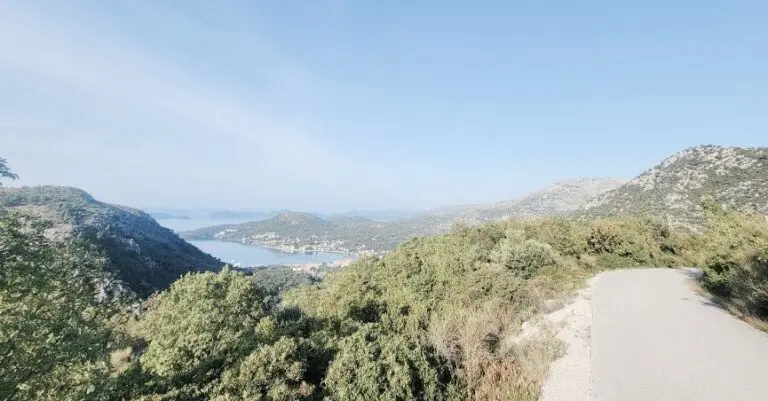
The hydroelectric dam appears as a landmark signalling the approach of the lake — a moment of transition after the long forest climb. Shortly after, the sign for Alouette Lake Park confirms you’ve arrived.
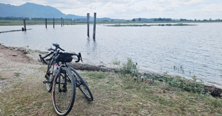
Alouette Lake sits within Golden Ears Provincial Park, stretching roughly 16km through the mountains east of Maple Ridge. The east side of the lake — where this route delivers you — is accessible only by boat from the main park entrance, or by bike or foot along this gravel road. There’s something satisfying about arriving somewhere by effort that other people reach by engine.
From across the lake, you can see the packed day-use area on the west side, with its busy beach and facilities. Over here it’s quieter. Outside peak season, you might catch smoke drifting lazily across the water from the provincial park campsites further north — a sight that makes the place feel genuinely remote despite being an hour from Vancouver.


The East Beach Marine Campsites
The East Beach Marine Campsites are first-come, first-served — no reservations, which means no guarantee of a spot in peak summer, but also no planning required for a spontaneous overnight. They’re small gravel pads, not particularly spread out, so privacy is limited. What they offer instead is access: a narrow strip of sand and pebble beach, cold, clear lake water, and a position on the east shore that catches light differently from the crowded west side.
There’s an outhouse with toilet paper and a food cache for overnight guests. Basic, functional, exactly right for a bikepacking camp.
The evenings here are something. The sun drops behind the mountain relatively early, which means golden hour arrives sooner than you might expect and lingers in that extended dusk glow that comes from the sun being below the peaks, but the sky is still lit. The surrounding mountains catch the light first — illuminated ridgelines against a deepening sky — and then gradually fall into shadow as the lake surface holds the colour longest.
You can still hear the sounds of the day-use area across the water in the early evening, but it closes at dusk, and the noise settles. What you’re left with is the lake, the peaks, the occasional splash, and whatever you brought for dinner.
April 2026 was warm in the day and dropped to around 5°C overnight — a reminder that early season camping requires more sleeping bag than you might hope for. Summer is the more comfortable season for this route; the nights are warmer, and the lake is inviting rather than bracing. That said, the shoulder season light is extraordinary.


The Ride Home
The route back is the same road in reverse — which sounds anticlimactic and isn’t. Seeing the landscape from the other direction, with different light and different legs, makes it feel genuinely different. The elevation profile works in your favour on the gravel section: what was a steady uphill is a gentle rolling descent out.
There is one hill on the return — I remember it very clearly from the first trip, when it nearly finished me. By April 2026, I crested it without drama. That improvement — felt in the legs rather than measured on a screen — is the clearest marker of how far the riding has come since summer 2023.
As a Day Ride
This works just as well without the overnight gear, if a full bikepacking setup isn’t what you’re after. The return distance of roughly 70km is a solid day ride, and arriving at the lake for lunch and a swim before riding home is its own kind of reward. The gravel section and the lake access make it feel like more of an adventure than a typical road ride of the same distance.
If you want extra kilometres at the start, the Fort to Fort Trail and Derby Reach add a scenic warm-up loop before the main route begins.
Practical Notes
What to bring: Water — there are limited services on the gravel section. Snacks for the climb. A waterproof layer, regardless of the forecast (this is BC). For overnight: a properly rated sleeping bag (don’t underpack this one), a sleeping pad, food, a camp stove if you want hot food, and bear awareness — food cache at the campsite, use it.
Bikes: We ride gravel bikes. Road bikes with some tyre clearance would manage the gravel section fine. Mountain bikes would work, but lose efficiency on the long paved sections. A gravel bike is the right tool.
The gate. There’s a path to the right of the yellow gate, near the small parking area. Use the path. You’re welcome.
Campsite: First-come, first-served. No reservations. Outhouse and food cache on site. Arrive by mid-afternoon in summer if you want a spot. In shoulder season (April, September), you’ll likely have your pick.
Getting to Fort Langley Drive and parking in Fort Langley — there’s parking near the historic site and the town centre. The route starts from here and returns here, so it’s a clean car-based logistics situation.
Pin me for later…

More BC Biking posts:
More Bike-Packing posts:

Cycle the Kettle Valley Rail Trail BC: To Myra Canyon

Weekend Bike-packing: Alouette Lake via Fort Langley
Japan Cycle Touring Packing: 2 Short Trips
Lake Biwa: A 3-Day Cycling Guide To Japan’s Iconic Lakeside Loop
Cycling the Shimanami Kaido Route in Japan: Full Itinerary