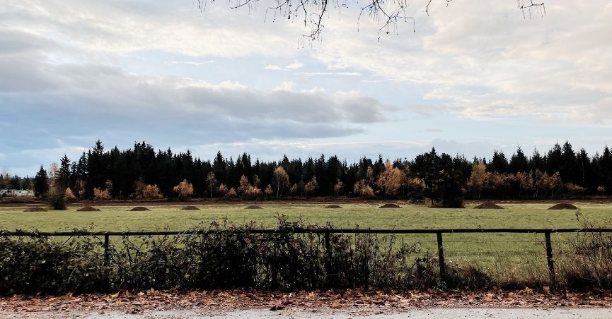
The Derby Reach area near Fort Langley, BC, is a scenic and historically rich stretch along the Fraser River. This route is one of our regulars and can be done as a leisurely scenic ride or a fast-paced workout. We certainly do both. At around 40km, it’s perfect for those Garmin Weekend 40K badges (if you are a badge hunter like us). This loop is accessible for beginners as it is mostly flat with a few hills, and easy to extend if you want more distance. The terrain is mostly paved roads, with optional gravel trails. My favourite time to go is early morning when the mist still clings to the river.
This post covers the full route, what to expect on each section, and the best places to stop along the way
A Short History of the Area
Long before Fort Langley became the birthplace of British Columbia, this stretch of the Fraser River was a busy place. The Hudson’s Bay Company established the original Fort Langley at Derby Reach in 1827, using it as a fur trading post and salmon processing hub. The fort relocated 5km upstream to its current location in 1839 — partly due to flooding, partly for better agricultural land — and Derby Reach quietly returned to farmland.
The village of Fort Langley, which grew around the second fort, has its own remarkable chapter. In 1858, during the Fraser River Gold Rush, the fort became the administrative capital of the new Colony of British Columbia.
Threading through it all is the Telegraph Trail, built in 1865 as part of the Collins Overland Telegraph Line — an audacious attempt to connect North America and Europe via an overland cable through BC, Alaska, under the Bering Strait, and across Russia. The project was abandoned almost immediately after a transatlantic cable was successfully laid. Still, the trail it left behind became one of Langley’s first transportation routes and remains today as the region’s oldest protected heritage site.
Fort Langley Bike Route Summary
- Length: 40 km
- Total elevation: 368 m
- Surface: paved (or some gravel)
- Bike lanes: a small portion of this route is separated bike lane, but many sections are cycling routes
- Note: there are a few train track crossings on this route, always ride across perpendicular to the tracks (so your tire doesn’t fall in), or dismount and walk across them.

Start
Fort Langley to Derby Reach
Start in Fort Langley. Come early to find street parking, especially on weekends. Have a pre-ride snack and coffee at Blacksmith Bakery. The Fort Langley area will be busy with cars and pedestrians as the day progresses, so be prepared to be assertive on the bike.
You can ride this route either way, though I do recommend riding it counterclockwise. The hills are gentler that way.
Head out of Fort Langley, first passing through some residential roads (a good warm up) towards Allard Crescent and the Derby Reach Park. Gravel optional add-ons: 1) Instead of turning on Billy Brown Road, you could ride over the bridge to Brae Island and ride through the park to Tavistock Point; 2) ride the gravel Fort to Fort trail path instead of the road.
Derby Reach is really pretty – unfortunately, from the road, you won’t have river views, but you can ride into the Derby Reach Park if you want the views. There are also public toilets here. If you choose the gravel trail, it will be more scenic in this section of the ride.


Derby Reach through Walnut Grove
This section finishes up the Derby Reach area, past some farmland, then into parts of Walnut Grove. Once you turn off Allard Crescent onto 208, note that the bike lane/road shoulder disappears, so stay as close to the side as possible, being conscious of vehicles. People are used to cyclists and runners on 208, so it’s not usually an issue. Optional: There is a gravel/sand section along part of 208.
We usually cut through Yeomans Crescent because it’s calmer than 96th, but it also has some lovely homes that we like to daydream about owning. You might have to wait a little for a break in traffic to cross to the far side of 96th, but usually not too long. 96th has bike lanes on either side.
There is a hill climb up 216th, so prepare yourself for a slow and steady pace. Fortunately, the climb is divided into two parts with a flatter section in the middle. Once you see the elementary school, know that you have a 1/2 km flatish section. The hill resumes at the signalled crosswalk (88b). The second half of the hill is gentler than the first. There is a bike/pedestrian path along 216 after crossing at 88th.

Telegraph Trail to Farmlands
Now you’ve earned your sweet downhill cruise with gorgeous farmland views. This section of Telegraph Trail starts with views to the river and mountains, past large fields and lovely farmhouses.
The next section has a few busy and tight turns. From Telegraph, turn left onto Glover Road, sometimes a little busy here. The next turn onto Rawlison Crescent is a sharp right on a bit of a downhill, so go slow and be prepared for it. There is a good shoulder/bike lane to turn into. To continue on Rawlison, you have to make a bit of a blind left turn. The section is on a curve, so any cars behind you can’t see you well, nor can you see what is coming very well. We usually slow our pace down so we have more time to look and decide when to go. If you are out early, this likely won’t be as much of an issue.
From Rawlison, you are heading into the section with the most elevation gain. I always struggle with the hill on 240th; it starts as a continuous uphill, then becomes a bit more acute towards the end. A good place for training pacing and pushing through fatigue. There is a separate bike path section along 80th. Turn back onto Telegraph Trail.


Farmlands back to the Fort
Having done most of the hard work already, enjoy this section. Telegraph Trail offers beautiful farms and fields on either side. This is often where I am commenting on how nice it is to be out for a ride, or how lovely the day is. Something about sunshine riding along these roads that gets me every time.
I’ve mapped out the route as a nice, clean 40 km, but you have options at this point. You could extend the ride by continuing south on 248th. Here are the options on where to turn left to connect back to 264th for the rest of the route:
- 56 Ave, adds 4 km
- Robertson Crescent adds 10 km
- Fraser Highway, add 12 km and does have wide shoulders/bike lane
- 24 Ave, adds 16 km
- 16 Ave, adds 20 km
- 8 Ave, adds 23 km
- 0 Ave, adds 27 km (I have a separate 0 Ave route that I will post too)
Regardless of how far you choose to ride, the area is mostly farms, and so lovely. On clear days, you can often see Mt. Baker to the south (Cascade range) and the Coast Mountains to the north, like Golden Ears.
You do have one steep downhill section along 264th. It’s usually not too busy on the road, but just be aware of the cars around you. There are some gentle curves at the start of the descent, but it straightens out near the end, so you can just cruise. Now heading back toward the river and Fort Langley. You are riding on a busier road, but there are good shoulders.

Pin me for later

More BC cycles


Leave a Reply